고정 헤더 영역

상세 컨텐츠
본문 제목
Hottest Day in 122 Years: Yangsan Hits 40.3°C Ahead of Typhoon Dolphin
본문
반응형
[26.07.29] Gyeongnam Yangsan Hits Record-Breaking 40.3°C Heatwave… Double Heat Dome and Foehn Effect Combine, Will Typhoon Dolphin Be a Game Changer?
On July 29, daytime temperatures in Yangsan, South Gyeongsang Province, soared to 40.3°C, setting an all-time record since official weather observations began in 2008. Busan also recorded 38.8°C, marking its hottest day in 122 years of modern meteorological history. As extreme heat conditions sweep across the Korean Peninsula, here is a comprehensive breakdown of the causes behind this unprecedented heatwave and the upcoming weather forecast.
1. Yangsan Hits 40.3°C & Busan Reaches 38.8°C… Extreme Heatwave Sweeps Yeongnam Region
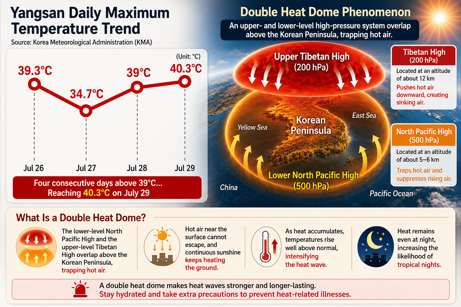
According to the Korea Meteorological Administration (KMA) disaster prevention weather platform, the temperature in Yangsan, South Gyeongsang Province, reached 40.3°C at 3:34 PM on July 29, marking the highest temperature nationwide this year. This broke the region's previous high of 39.3°C set just three days earlier on July 26 by a full degree, setting a new peak since records began in December 2008.
This marks the third consecutive year that temperatures exceeding 40°C have been recorded in South Korea, and the second consecutive year that a 40°C reading occurred in July. Meanwhile, Busan's representative observation station in Daecheong-dong registered 38.8°C at 2:56 PM, making it the hottest day in the city since modern meteorological observations began 122 years ago in April 1904. In Deokcheon-dong, Buk-gu, unofficial automated observations reached as high as 39.2°C.
Other locations across the Yeongnam region experienced severe heat as well, including Gimhae (39.0°C), Buk-Changwon (39.0°C), Uiryeong (38.4°C), Guryongpo in Pohang (38.3°C), and Jangsaengpo in Ulsan (38.3°C). The capital area was not spared either, with Gangnam and Nowon in Seoul hitting 35.0°C and Geumsa in Yeoju, Gyeonggi Province reaching 36.0°C.
Yangsan reaches 40.3°C and Busan hits 38.8°C! With temperatures topping 40°C for three consecutive years, extreme heatwaves once considered rare anomalies are rapidly becoming a new normal.
2. 'Double Heat Dome' and Basin 'Foehn Effect' Create Furnace-Like Conditions
The sudden surge in temperatures across Yangsan and the surrounding Yeongnam region stems from a combination of high-altitude pressure systems and distinct regional topography. Meteorologists point to a 'Double Heat Dome' trapped over the Korean Peninsula as the primary catalyst.
The Tibetan High in the upper atmosphere and the North Pacific High in the lower atmosphere stacked together, sealing off the peninsula and preventing surface heat from escaping. On top of this, a adiabatic heating phenomenon—commonly known as the Foehn effect—exacerbated the situation as persistent westerly winds blew across surrounding mountains, compressing and heating the air as it descended.
Furthermore, Yangsan is situated in a basin surrounded by mountains. The compressed, heated air funneled directly into the urban center and remained trapped, driving temperatures to unprecedented levels. In response, the KMA issued a 'Severe Heatwave Warning' for Yangsan, Gimhae, Miryang, Uiryeong, and Changnyeong, which triggers when perceived temperatures are expected to exceed 38°C.
Key drivers of the heat spike: A 'Double Heat Dome' formed by stacked high-pressure systems combined with adiabatic heating over mountainous terrain to trap intense heat inside the basin.
3. Tropical Night Record Shattered… Unrelenting Sweltering Conditions Day and Night
Beyond daytime heat, nocturnal temperatures are breaking historical records across South Korea. KMA statistical data indicates that the nationwide average number of tropical nights from June 1 through July 28 reached 8.5 days.
This is the highest number on record for the same period since the nationwide observation network was established in 1973. It surpasses previous record-setting heatwave years, including 1994 (7.5 days) and 2024 (7.0 days), resulting in prolonged sleepless nights across the country.
KMA officials predict that under the continued influence of the dual high-pressure systems, severe heat with daytime perceived temperatures ranging between 35°C and 38°C—along with tropical nights—will persist for the foreseeable future. Authorities strongly advise avoiding outdoor work and taking precautions against heat-related illnesses.
Unbroken heat through the night! The nationwide average number of tropical nights reached 8.5 days for June–July, setting an all-time record since 1973.
4. Super Typhoon 'Dolphin' Moves North… Will It Disrupt the Heatwave?
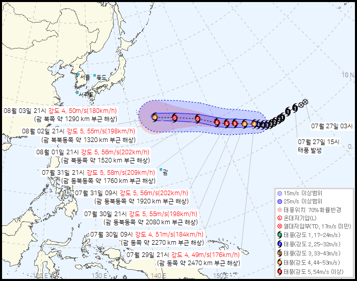
Amid suffocating heat, attention is shifting toward Typhoon Dolphin (Category 13), which is moving northwest across the Pacific, to see if it might alter atmospheric patterns. According to a KMA report issued on the morning of July 29, Typhoon Dolphin was located approximately 2,720 km east of Guam, moving west-northwest at 16 km/h.
Typhoon Dolphin is expected to intensify rapidly into a Category 5 super typhoon by early August, with central pressure dropping to 905–915 hPa and maximum sustained winds reaching up to 58 m/s. Current track forecasts indicate that Dolphin will head toward the waters southeast of Tokyo, Japan by August 3, making a direct landfall on the Korean Peninsula unlikely.
However, even distant typhoons can shift surrounding high-pressure systems. For instance, Typhoon Bavi earlier this month helped push the North Pacific High southward, bringing temporary relief to central South Korea. While Dolphin is currently projected to pass far east of Japan, meteorologists are closely monitoring its trajectory for any potential disruption to the heat dome.
- "With Yangsan hitting 40.3°C and Busan at 38.8°C, southern coastal areas are feeling significantly hotter than traditionally warm regions like Daegu."
- "Trapped under a double heat dome, relying on air conditioning through tropical nights feels essential now."
- "Even if Typhoon Dolphin passes away from Korea, I hope it helps break up the intense high-pressure system locking in this heat."
Super Typhoon 'Dolphin' tracking northwest! Expected to reach Category 5 intensity; weather agencies are monitoring whether its movement will shift high-pressure systems over Korea.
| Category | Key Facts & Summary |
|---|---|
| 1. Regional Temperature Peaks | Yangsan 40.3°C (All-time high) / Busan 38.8°C (Highest in 122 years) / Gimhae & Buk-Changwon 39.0°C |
| 2. Causes of Heat Spike | Stacked Tibetan and North Pacific Highs ('Double Heat Dome') + Foehn wind effect trapped in basin terrain |
| 3. Tropical Night Status | June 1–July 28 average of 8.5 tropical nights nationwide (Ranked #1 since observation network setup in 1973) |
| 4. Typhoon Dolphin Outlook | Moving WNW from Guam; projected to reach Category 5 super typhoon strength before tracking east of Japan |
| 5. Official Health Advisory | 'Severe Heatwave Warnings' issued for 5 Gyeongnam regions; outdoor work suspension and hydration strongly advised |
[Key Summary] 5 Takeaways on Yangsan 40°C Heatwave & Typhoon Dolphin
1. Record 40.3°C in Yangsan: Yangsan hit 40.3°C and Busan reached 38.8°C on July 29, breaking local meteorological records.
2. 3-Year Consecutive 40°C Heat: South Korea has recorded temperatures over 40°C for three consecutive years (2024–2026).
3. Double Heat Dome Effect: Upper and lower atmospheric high-pressure systems combined with mountain winds to lock in heat.
4. All-Time High Tropical Nights: Average tropical night count reached 8.5 days, the highest since 1973.
5. Typhoon Dolphin Variable: Super Typhoon Dolphin moving northwest; atmospheric impact on the heat dome remains under observation.
Related Tags (9): July_29_2026, YangsanHeatwave, 40CHeatwave, BusanRecordTemp, DoubleHeatDome, FoehnEffect, SevereHeatwaveWarning, TyphoonDolphin, TropicalNightRecord
728x90
반응형
그리드형(광고전용)
댓글 영역